LYCIAN LEAGUE
The Teke Peninsula, which stretches into the Mediterranean Sea between the gulfs of Antalya and Fethiye, was known as Lycia in ancient times. The Mediterranean Sea marked the southern boundary of this region, while its eastern, western, and northern borders evolved over the years. Ancient authors noted that the Bey Mountains, the Akdağ range, and their northwest extension, beginning just west of Antalya and moving southwest, formed the northern limit of Lycia. In his renowned epic, the Iliad, Homer recounts how the Lycians fought alongside the Trojans against the Achaeans, led by Glaukos and Sarpedon.
Following Alexander the Great’s death, the Lycians entered a new era. From 309 BC onward, the Ptolemies, who governed Egypt, ruled for nearly a century, a time when the Lycian language faded and was supplanted by Greek.
Between 197 and 167 BC, the region fell under the control of Antiochus III of Syria. Lycia achieved its independence from Rome in 167 BC. Inscriptions and coins from this era reveal that 23 cities united to form the “Lycian Union,” with Xanthos serving as its capital, and coins were minted in the name of this union.
DAY 1 FETHIYE
Fethiye, renowned for its cultural richness, natural attractions, and geographical features, stands out as one of the significant tourist destinations in Türkiye. It is well-known for its artistic creations attributed to the Persians, Lycians, Carians, and Romans. This delightful county is situated in a bay within the Fethiye Gulf, where numerous large and small islands are dispersed. The back of the bay is enveloped by pine forests.
DAY 2 KAYAKÖY (Ghost town) Ovacik – Faralya village walk
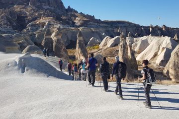
Our first stop will be Kayaköy. The story of Kayaköy, located 8 kilometers south of Fethiye and known as Karmylassos in ancient times, goes back to the 3rd millennium BC. However, according to linguistic evidence, the remaining buildings of this city have not yet been excavated from the 4th century BC. During that time, the city was called Levissi, and the building complexes we see on the hillside were constructed by the Greeks. The city, which was deserted due to the rights given to minorities in the later years of the Ottoman Empire, has turned into a ghost town, with nature causing the wooden doors, windows, and roofs to deteriorate. When it was inhabited, the abandoned city had between 350 and 400 houses, each no larger than 50 m2, designed to provide clear views and light. These buildings are mostly two stories tall, with the lower levels serving as cellars, and they include underground cisterns for collecting rainwater from the roofs at their entrances. In addition to the homes, there are many chapels, two large churches, one school, and one customs building scattered throughout the area. After visiting Kayaköy, we will drive to Ovacık. Today, we will walk about 14 km. We’ll drive to the official starting point of the Lycian Way where we will begin our 14 km hike. We’ll head south up onto the slopes of Baba Dagi. After a short walk on the trail, we will have the opportunity to see Turkey’s most famous lagoon, Ölüdeniz Lagoon, as well as the beach. As we pass through pine forests and small villages, after climbing 750 meters, we will descend to Faralya, which is situated on a small plateau above the Butterfly Valley. (14 km/5 hrs-800 m ascent/800 m descent).
DAY 3 FARALYA – Walk to Kabak Beach and Gey Village
Faralya village settlement is located on a south-facing slope at the foothills of Babadağ, just above the Butterfly Valley, in a very special location in terms of location and flora. Today we are going to about 18 km. via Alınca village to GE(GEY).
In the morning we will walk uphill with the beautiful of the coastal line and pine forests. At some stage we will follow an old route through a blind valley, we will travel towards the far village and beach of Kabak. We will then ascend through pine forests to get to Alinca. We can have a tea break with the locals at a vantage point overlooking the sea before moving on. . (18 km/7 hrs walk-900 m descent/500 m ascent)
DAY 4 GEY- Walking to Sidyma ancient city -Patara
Today our hike will end at an site called Sydima. We will hike around 12 km. Todays terrain is different. The route proceeds through agricultural land characterized by expansive fields, subsequently transitioning to breathtaking coastal vistas. The trail ascends further through extensive plains and pine woodlands, before gradually descending towards the ancient city of Sidyma.
Sydima, now referred to as Dodurga, is inhabited by locals who reside amidst the remnants of the Roman Period. These ruins encompass an acropolis, stoa, watchtower, theater seating, bath, church, and grand royal tombs. The stoa, situated at the center of the village, features columns that remain intact. The rock tombs resembling pigeon nests and those shaped like sarcophagi serve as symbols of Sidyma. 12 km/5 hrs walk-450 m ascent/600 m descent)
DAY 5- Delikkemer – Patara – Kaş
Following an unbelievable stone made pipeline aquaduct, we are walking to one of the capitals of Lycian Union From Delikkemer to Patara Our start point will be at the aqueduct. This one of the famous one in Türkiye, it is called the Delikkemer Aqueduct. It presents a fascinating journey through historical times. Built during the Hellenistic era, it served extensively throughout the Roman Empire. This remarkable aqueduct once supplied fresh water to the ancient city of Patara.After the hike we will have a chance to wonder around the ancient city of Patara.The city served as a significant port for Lycia, thanks to its secure harbor, and was recognized for housing one of the earliest parliamentary structures. It functioned as the capital of the Lycian Kingdom and became a favored destination for tourists in the ancient Lycian area. Drive to Kas .(12km/5 hrs-150 m ascent/250 m descent/100 m ascent). Overnight in Kaş
DAY 6 APERLAI- boat tour in Sunken city of Kekova – Cirali
After a 45 mnts transfer, we start to walk down to Aperlae village that is settled on two shores of a peninsula. Ancient sarchophagi, huge buildings and village houses are meeting us on the way .Envision a modest port city in Lycia renowned for one of the most sought-after colors of antiquity: royal purple, also known as imperial purple or imperial dye. This reddish-purple natural dye is derived from various species of predatory sea snails. As per certain accounts, this color, which was notably challenging to procure due to its costly production process, was manufactured in the city of Aperlei and distributed to nobles across numerous regions of the world via trade. After 6.5 km walk we will end up at the beach where our boat waiting for us for an amazing boat tour in the crystal clear turquoise water. We will have a chance to see the sunken city’s ruins of Kekova island and the famous Sinema village. Aftre tour drive to cirali.
Overnight in cirali
DAY 7 Cirali – eternal flmaes at Chimaera –Ulupinar walking- Antalya old town
In our last walking day, Leaving our accomodation, we are walking up to eternal flmaes at Chimaera first,Beneath these flames lie the remnants of the temple dedicated to Hephaistos and the continuing to Ulupınar village. At the last 1 km we will arrive to famous ancient site Chimera. The site features numerous small fires that perpetually burn from vents in the rocky slopes of the mountain.we will ascent upto 530 metres and descent to sea level.Having our lunch at a local restaurant, After the hike there is 90 mins drive to Antalya old town know as Kaleici. Kaleiçi, a stunning area in Antalya, has a rich history dating back to ancient times. It offers visitors a glimpse into the past with its charming houses, marina, narrow streets, and remnants of Greek, Seljuk, and Ottoman architecture.
(3-4 hrs walking)
DAY 8 ANTALYA DEPARTURE
After breakfast transfer to Antalya airport


Tour Reviews
There are no reviews yet.
Leave a Review